
Forget the usual choice between a coastal highway and a mountain pass. A Great River Road trip follows a different landmark: the Mississippi River, from its modest beginnings in Minnesota to the delta country of Louisiana. Along the way, forested lakes give way to limestone bluffs, working river ports, and music-filled cities. The scenery changes gradually, which makes this journey memorable.
The Great River Road is a network of connected highways, not one uninterrupted road. Its wider route covers roughly 3,000 miles across ten states, sometimes with alternatives on opposite banks. You do not need to drive every branch. The best approach is to choose a direction, allow time for stops, and let the river towns set your pace.
Where the Great River Road begins and ends
The northern end is at Itasca State Park in Minnesota, where the Mississippi emerges from Lake Itasca. The southern end is near Venice, Louisiana, close to the river’s Gulf outlet. Between them, designated routes pass through Minnesota, Wisconsin, Iowa, Illinois, Missouri, Kentucky, Tennessee, Arkansas, Mississippi, and Louisiana.
Look for the green pilot’s-wheel symbol on roadside signs. Because this route uses different state and local highways, navigation apps sometimes favor faster roads that leave the byway. Compare directions with an official Great River Road map, particularly near bridges and cities.
Build your itinerary around landscapes, not state borders
A Mississippi River road trip is better when you think in regions. Trying to collect every state name can produce rushed days and little time beside the water. This north-to-south Great River Road itinerary highlights places worth exploring without pretending there is only one correct route.
Upper Mississippi: Lake Itasca to the Twin Cities
Begin at Lake Itasca, where stepping across the young river is a striking contrast to the huge waterway farther south. Follow Minnesota’s route through lake country toward Minneapolis and Saint Paul. Make time for short walks, viewpoints, and the shift from quiet headwaters to urban riverfront. This northern leg works especially well for travelers who prefer parks to busy attractions.
Bluff country: Minnesota, Wisconsin, Iowa, and Illinois
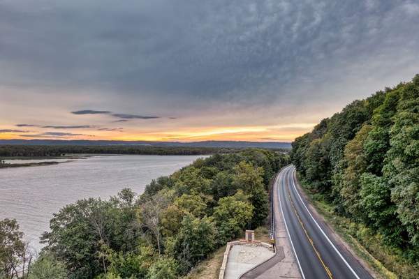
South of the Twin Cities, the Mississippi valley becomes more dramatic. Around Red Wing and Wabasha, steep bluffs frame long river views. Across the water, Wisconsin communities such as Alma and Prairie du Chien offer another perspective on the same landscape.
Dubuque, Iowa, makes an excellent overnight stop, with riverfront attractions and nearby bluff-country scenery. On the Illinois side, historic communities and occasional inland detours, including Galena, reward travelers interested in older downtowns. Do not expect every attraction to sit directly on the signed route.
Middle Mississippi: Hannibal and St. Louis
Missouri’s Hannibal brings the river’s literary history into focus through its association with Mark Twain. Farther south, St. Louis makes a natural pause: the Gateway Arch and riverfront connect the Mississippi with American trade and westward expansion. Traffic and complex junctions can interrupt the scenic rhythm here, so plan city visits separately from quieter driving days.
Lower Mississippi: Memphis, Vicksburg, and Natchez
Memphis combines riverfront views with a rich musical heritage. Continuing south, Mississippi’s Delta landscape is flatter and wider than northern bluff country. The river often lies behind levees, so uninterrupted water views are not guaranteed.
Vicksburg is a meaningful stop for Civil War history, particularly at its national military park, while Natchez offers historic architecture and elevated river views. Give these places more than a quick photograph. The lower river tells its story through communities, commerce, food, difficult histories, and music as much as through scenery.
Louisiana: Baton Rouge, New Orleans, and Venice
The final region exchanges bluffs for wide waterways, wetlands, and commercial river traffic. Baton Rouge and New Orleans are worthwhile bases, although both require urban driving. If you continue toward Venice, check fuel availability, road conditions, and access to planned stops. This is a working delta landscape, not a conventional beachfront finish.
How many days should you allow?
For a full north-to-south journey, two to three weeks leaves room for museums, walks, and spontaneous stops. A faster drive is possible, but the designated byway is often slower than an interstate, and mileage varies according to the branches you choose.
With three or four days, focus on the bluffs in southeastern Minnesota, western Wisconsin, and northeastern Iowa. With five to seven days, explore the upper river more deeply or connect Memphis, Vicksburg, Natchez, and New Orleans. Ten to fourteen days permits a broad overview with selective stops; two to three weeks allows a more relaxed journey.
For example, base a four-day trip around La Crosse, Wisconsin. Spend one day exploring nearby viewpoints and river towns, another in the Wabasha area, a third toward Prairie du Chien, and the last returning by the opposite bank where bridges make sense. You will see varied scenery without constantly packing and changing hotels.
Practical planning tips for the river route
Choose the season for your region
Late spring through autumn generally offers comfortable conditions in the Upper Mississippi, though spring flooding can affect riverfront roads. Autumn color makes bluff country particularly appealing. Summer brings festivals and long days, but also humidity and busy attractions. Northern winters can mean snow and ice; the southern corridor is often milder.
Plan around crossings, detours, and viewpoints
Download maps before leaving larger towns, and check state transportation alerts before driving. The river is not always visible from the highway. Seek overlooks, public parks, riverwalks, and interpretive centers rather than expecting constant windshield views. Check bridge locations before switching banks, since a crossing may be farther away than it appears.
Reserve lodging early for festival weekends and fall-color periods. Keep some fuel in reserve on quieter stretches and check access restrictions for a large RV. A road trip packing checklist can help when your journey spans several climate regions. If you are comparing routes, consult a guide to America’s best scenic drives.
Frequently asked questions
Is the Great River Road one continuous highway?
No. It is a signed network of federal, state, and local roads following the Mississippi corridor. Some sections offer designated routes on both banks.
Can you drive the Great River Road in a week?
You can cover substantial ground, but an end-to-end trip would be rushed. A regional itinerary leaves more time for historic sites, walks, and memorable river towns.
Where are the best Mississippi River views?
Upper Mississippi bluff country around southeastern Minnesota, western Wisconsin, and northeastern Iowa stands out for elevated vistas. The lower river is compelling for its wetlands, levees, and working ports.
Do you need a special vehicle?
No. Most designated stretches are ordinary paved public roads suitable for a standard car. Check conditions and local restrictions before taking remote detours or driving a large RV.
Let the river shape the trip
The pleasure of the Great River Road is not reaching the Gulf as quickly as possible. It comes from seeing how one river connects dramatically different regions, from Minnesota forest to Louisiana delta. Choose manageable days, stop when history or scenery catches your attention, and treat towns as destinations rather than interruptions. That is how a long route becomes a road trip worth remembering.